Frensham Little Pond

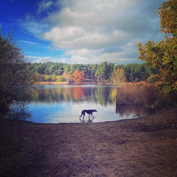
The village of Frensham and its Little and Great ponds can be found near the town of Farnham. The name Frensham comes from “Frena’s ham”. Frensham Little Pond, once called Crowsfoot, was built in 1246 by order of the Bishop of Winchester, William de Raleigh.

Limpsfield High Chart

The High Chart, adjacent to Limpsfield Chart, is a large area of ancient woodland owned by the National Trust and the Titsey Estate. The word “chart” comes from the Old English “chert”, which means rough ground.

Norbury Park West

Norbury Park is a 530 hectare historic parkland comprising mixed wooded and agricultural land, which was alluded to in the Domesday Book of 1086. Grade II listed on the Register of Historic Parks and Gardens, it occupies mostly prominent land reaching into a bend in the River Mole and is part of the Mole Gap to Reigate Escarpment Special Area of Conservation.

Reigate Hill and Colley Hill

Reigate Hill, at a height of 771m above sea level, is described by the National Trust as “a spectacular escarpment with sweeping views across the Weald” and that sums it up perfectly. This stretch of the North Downs hill top boasts a rich history, home to Reigate Fort, the Wing Tips memorial sculpture and the Inglis Memorial.

Norbury Park East

Norbury Park is a 530 hectare historic parkland comprising mixed wooded and agricultural land, which was alluded to in the Domesday Book of 1086. Grade II listed on the Register of Historic Parks and Gardens, it occupies mostly prominent land reaching into a bend in the River Mole and is part of the Mole Gap to Reigate Escarpment Special Area of Conservation.

Hankley Common – Atlantic Wall

Hankley Common is a 560-hectare nature reserve near the village of Elstead in Surrey comprising lowland heath and woodland. The site is part of the Thursley, Hankley and Frensham Commons Special Area of Conservation and a Site of Special Scientific Interest.

Banstead Woods

An ancient woodland thought to have been owned by Anne Boleyn, Banstead Woods was alluded to in the Domesday Book of 1086 and, in the medieval period, sheltered the royal deer. These days, it is local nature reserve and site of Special Scientific Interest, infamous for the swathes of vibrant bluebells that carpet the floor in the springtime.

Coulsdon – Happy Valley

Happy Valley near Coulsdon makes up part of the Farthing Downs. It was purchased under the Green Belt Scheme in 1937 by Surrey County Council, the Urban District Council of Coulsdon and the London County Council. It is an area of managed open countryside of just over 250 acres of downland grass and ancient woodland slopes (Devil’s Den Wood), dominated by a steep‐sided dry valley at the centre and considered an important reserve for all kinds of animal and plant life.

West End Common

West End Common is a 70.3-hectare (174-acre) Local Nature Reserve and part of Esher Commons, which is a Site of Special Scientific Interest. The River Mole runs along one edge of the common, which also boasts six ponds and wet areas.

Website Powered by WordPress.com.

Up ↑